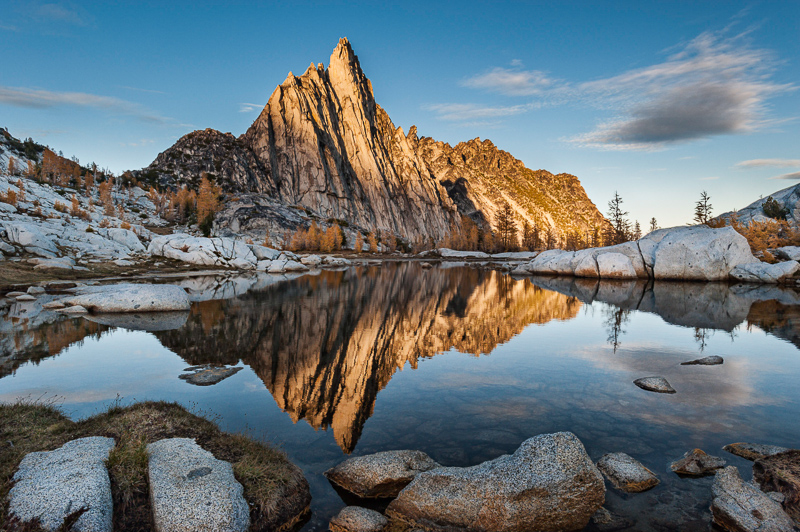
The Enchantments: the name speaks for itself. A magical place, with names like "Gnome Tarn", "Rune Lake", "Valkryie Lakes" (the original names). Land of high alpine larch, mineral infested blue waters, glacial boulders. Mountain goats bound like unicorns all over. So tempting, that to preserve it, the FS only grants overnight access by lottery in the dark of winter. Of course I had to go. We won -- if you use the term loosely-- a permit for the Snow Lakes zone, which, while not the Core zone I wanted, was acceptable. All spring and summer my dreams were filled with golden larch against blue skies.
core zone old map here
As things go, this was a summer of both extremes: perfect backpacking weather, and imperfect fitness. I just couldn't get ahead on my arthritis and for the first time in 6 years, I voluntarily took 6 weeks off of everything. From my backpack at the beginning of July until around the 10th of August, I rested. Unfortunately, this didn't help at all. Knowing a challenging hike was looming, I restarted with running and weight lifting. The weather held. We made plans, splurged on some new daypacks, daydreamed. My health improved. I felt strong again.
Two weeks out, Scott developed a bad bout of diverticulitis. Two antibiotics three times a day and he could barely walk. The First Sign. Then, the forecast started to tank. Gorgeous, clear and dry until the day we would hike in. The Second Sign. But everyone knows weather changes at the last minute. Then Gabe came down with Hand, Foot and Mouth disease on Wednesday. BABY DISEASE! In high school! The Third Sign. The day before we left, Caitlyn came down with a sore throat (the beginning of HFM disease). The Fourth Sign. She wasn't feeling bad other than that though, so I ignored them all, and focused on the trip I'd built up in my mind all summer. Then I received news that a very important court date for a friend was scheduled at 9am the morning of the 25th-- in the midst of the trip. The Fifth sign. I was dense.
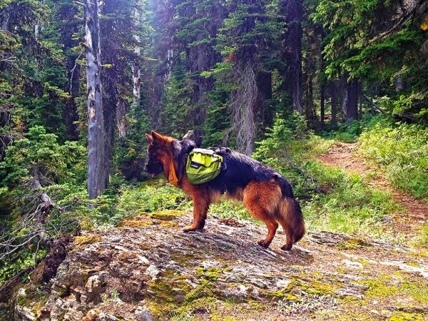
We drove to Wenatchee Monday afternoon to spend the night. It was so odd to me to head West to go backpacking instead of East. Wrong, somehow. After we arrived, we became concerned our packs were too heavy, so we went through and lightened Scott's. I was worried he'd have an attack up there. We trimmed some of his and added a little from mine, as they weighed the same. This burned me a little, even though I was in better shape than he was. His ended up around 42lbs with water and mine around 40lbs. He was thinking about the long climb up Aasgard Pass. Speaking of....there's two main ways into the 'Chants. One , the 'traditional' way, is up Snow Lakes trail. This TH starts somewhere around 1300' and gains about 6000' by the time it enters the Core zone (lower Enchantments), and it's 10 miles. The Stuart lake TH is higher by a couple thousand, and is only 1700' over about 5 miles to Colchuck Lake. However, you then have to cross a boulder field to round the lake to make it to the bottom of Aasgard Pass: a vertical mile that gains about 2300'. It is both risky, dangerous and yet young children do it, dayhikers do it, 75 year olds do it. It's an anomaly. I thought it would be easier overall if we got a Core permit to go in that way.
Bright and early, Tuesday the 23rd we hit the ranger station in Leavenworth. Scott's cousin graciously met us there to give us a ride to the Stuart Lake TH if we scored a permit. We were the only ones there; the Ranger said it was the first time she could remember not having to do a drawing for the core permit. Score! The thought did cross my mind that the weather might have something to do with it, but it didn't look
that bad. A small storm that night, and rain... well, we had rain gear. Onward.

Boy, we look optimistic. We made short work of the first few miles, even with numerous stops to adjust this and that (and dial in my new boots). We decided to go ahead and put our rain covers on our packs, as it kept drizzling on and off. I'm glad we did. The trail was easy until the last mile, and then, while not 'hard', it's definitely grunt-worthy with full packs on. We met several people on the trail. I thought this would be an issue for me-- the first group of men we met were aghast that we were going up Aasgard that same day. Only one of the men, the older one, said 'Ah, you can do it. Just be slow and careful'. Not that encouraging for Scott. He is the caution to my impetuousness. Then we met a couple, probably ten years or so older than us, and they were far more upbeat. They reassured us we were going in the 'preferable' way and they'd done it the other way before. They said to reassess after the boulder field, which we thought was reasonable. Due to the rain, I didn't take much for pictures.
Me, looking like a hobbit for some reason (I swear I was standing upright!)
Looking back the way we came:
First view of the lake and Aasgard Pass:
West end of the lake, as we went past:
The boulder field sucked. The gal had said to me: "At the beach at Colchuck, you can decide whether you'll want to continue up. You'll have already done something hard". She was right. It wouldn't be hard with a day pack on, but with a full backpack, in the rain, it's a bitch. We met a group of about 6 people, 4 guys and two gals, that cheered us on and mentioned Inspiration Lake as a place to camp. We hit the beach, chatted with a couple of women there and went a little ways up to sit and eat a bar and drink. We felt good, we felt ok, even looking up at the pass. It didn't look so bad.
We headed up. Time: 2:27pm
Surprisingly, it wasn't too bad. Grunt work for sure. You just follow cairns and more cairns. "Stay left", everyone said.
View of Dragontail about halfway up:
Looking back at Colchuck:
A few shots of the views:


Fatigue started with about the last quarter to go. We met a group of three guys, they also mentioned Inspiration Lake as more protected. We trudged on, and hit some large granite slabs that were slick from the rain. At this point, for a shorty like me, it's basically heaving yourself and your giant pack up. I was getting irritated and tired, and the cairns were few and far between. (I now wonder if we didn't go far enough 'right' at this point. I know there are several routes up and I think we got off track a little bit) A young couple appeared above us, on the way down, and when I gratefully acknowledged the human interaction and said "We've got to be close, right?" I was slightly crushed when he replied "Well, you're 85% of the way!" The fuck you say. The wind had started to pick up but we figured it was just the elevation. We finally drag ourselves up over the top, and the wind is blowing like crazy. By now, it's about 4:40pm. It's grey, grey and more grey, and the rain is hitting hard. We're chilled now with the sweat and the rain and wind and Scott insists we change shirts, so we try to get behind a big boulder and brrrrrrrrrrrr-- naked in the wind and rain while we frantically change into dry shirts, throw our down sweaters on and our rain shells. Ahhh. Much better. I snap a couple quick pics.


I am struck by the moonscape around me. It is so dreary and drizzly though, and bitingly cold with the intense wind that it's hard to stand and take pictures. Not to mention I don't want to ruin my wimpy iPhone.
So the thing is: I knew the 'Chants were the Land of the Traveled. I figured the trail would be, well, a trail. Notsomuch. It's cairns. Cairns and only cairns. The thing is, which cairns? There are cairns marking the way to this tarn, and that tarn, and this lake, and that lake. It was difficult in the growing weather to make sense of which way to go. I refer to the map and we trudge along, and am mostly able to make out where we are. The wind intensifies, as does the rain. We see three tents along the northern end of Isolation Lake, and they are blowing and battening down in the storm. STORM. DUH. This isn't just 'wind up high', the storm is here. The wind is a steady strong 30mph+. It's almost knocking me off my feet. We see an overlook and the lake is far below. Mistakenly, we think it might be Inspiration (it wasn't, it was Crystal) but it served its purpose: we know there is no way we're going to make it down that night. We start scouting for a tent spot and it's pouring rain now, except it's sideways with the wind. I see a grassy spot but Scott overrules it by pointing at the way the larch trees are bent sideways. We walk a bit further and boom -- he points to a perfect, small, sandy obvious tent spot encircled by larch not bent in a wind tunnel and it's decided. We throw our packs under the trees on the bit of grass and start to work. Our gloves were so soaked we had to ditch them. We'd used our leather ones to work up Aasgard, so this was our spare pair. No more gloves. At the last minute, I decide to keep them on just a little longer.
Since our tent is mesh and the storm was so bad, Scott decided to put up the fly first. As we're working on it, his fingers are already so frozen that the fly slips out and it's a good thing I had a freaking death grip on it. He'd already mentioned that to me-- that if we lost that fly, we'd be in the storm alright. A freaking shit storm, so I was holding on to it for dear life. Good thing I'd kept my gloves on just a bit longer. We get it up and we put the tent up underneath, so it stays relatively dry. By now, it's dark and I have to get out the headlamps. These are the times I'm grateful for Scott -- he never ever loses his cool. He kept calm and steady and when I stood there, chattering, he knew I was close to a moment and he said "Aimee. Get going". I start on blowing up the thermarests and getting the bags out and Scott starts to guy the tent...except there's no guy lines. For some reason, they're missing. Scott has to get cord and make them. Everything is covered in wet granite sand. About the time I get the beds ready, Scott's done with his makeshift guys. We don't have time to get the gear shed up because we're both soaking wet and chattering, he can't feel his fingers and I can barely talk. We pull the packs into the miniscule vestibules on either side, take off our boots and wet socks and change into dry clothes. Our down sweaters are soaked: the rain has driven into the necks of our shells and up our sleeves, I guess. We crawl into our bags, too tired to even eat, although somewhere in my brain I think we need the calories and I briefly think of making hot tea. But my fingers are too frozen. I rethink my decision to leave the MSR stove behind and bring my SnowPeak GigiPower canister, as it probably would take too long to boil. We slowly get warm as the storm intensifies.
The original forecast for the Enchantments, off the NOAA site, had said wind gusts up to 21mph. Scott and I spent the night blasted by gusts up to 70mph, with wind at least 45mph steady, and he swears there were gusts higher. All I know is after a few checks to make sure my shell wasn't blowing away and my boots were under the fly, I drew the cord of my bag around my face and tried to sleep. I realized I had only had about 1 liter of water and my mouth was insanely dry. We had about 1 liter left, and I forced myself to drink some. My breath blew clouds around me. Brrr. I was toasty warm, though, and there was a brief time I thought the storm was abating. The thing that kept going around in my mind though, was the forecast; it had read pretty much the same for the three days we were scheduled to be in there. We'd waited too long to tent up and things had gotten too wet. The other thing that I'd made a mistake in, besides the stove, was in leaving the GPS at home. In an effort to drop weight, Scott had suggested I leave it, as it's so traveled, so many people, not brushy and easy to find our way. Well, ok. Except....weather. Weather forecasts. Nothing to do now though. I think, it's easier to imagine worst case scenarios when it's just you, or just two of you. Everything goes through your head that could go wrong.
At 6:30 am, we both talked about waiting it out vs hiking out. We decided to see if it died down, and frankly, I'd barely slept all night, which is odd for me, as I usually love storms in tents, and I was warm. I set the alarm for 8:45am and we'd decide then. When it went off, the storm hadn't died down in the least-- it was still going strong, so we decided to head out. Scott wanted to just eat bars but I felt we needed some hot food, so he went out to get water and we forced ourselves to eat some beef stew with mashed potatoes. My Scottish friend had made the 'mince', as she calls it, for her husband and son and their 50mile hike through the Alpine Lakes Wilderness in August and it was delicious...other than that my SnowPeak, while working, took forever to boil and we didn't have 25 minutes to wait for it to fully rehydrate. Still, it was a wise decision.
Scott snapped a few pictures as we headed out. The peaks around were all in clouds, and frankly, I was concerned about our late start and the 13.5 miles we had ahead of us to get out. The rain had turned to hard sleet, pelting us in the face.
In retrospect, I wish I'd taken more pictures, but I just didn't want to risk the phone. I was already pissed I couldn't see the views, and the trail was a bit hard to discern, mostly because we were on a time frame now and had gotten off track a bit. With the weather the way it was, we just wanted to get out. It was strikingly beautiful though, and I could only imagine what it was like in better weather. Not even necessarily sun, but if only the damn wind or rain would stop. Both at once are the kickers. I was pleased with my shell though today and am still not sure how the down sweater got wet. I must've not had the wrists tight enough and the neck, well, win some, lose some.
We work our way to Inspiration Lake and realize it's a climb down. Everyone always talks about how flat the core is, but it's most definitely not. Well, there's two levels anyway. It's a bit challenging in the weather and again, I'm glad that we did not attempt it in the dark and storm of last night. I don't think good things would've come of it.
My favorite picture I think of the whole trip: be still, my beating heart. Look at that golden larch (you didn't think I was talking about Scott, did you? winkwink) I regret not stopping on Aasgard Pass in a little grove of golden larch and taking pictures.
We meet another group of guys, who had camped at Snow Lake the night before, and they asked us about how our tent held up. Fine, we say. They look at each other and mention that a tent blew over in the storm down there, and if ours held up, up there, we were ahead of the game. We looked at each other and thought someone doesn't know how to stake a tent out (HA. But the winds were that bad, really). Anyhow, I mention I'm glad it's all downhill and one of the guys says, "Well, yes, but you'll work for it. Trust me". Me and my big mouth. And he was right.
After we get down to Inspiration and Perfection, the trail is defined and we snap a few pictures. The wind is far less intense down here and we relax a bit.
I think, according to the map, that Prusik Peak is here on the left, but it's covered in clouds. Effer.
Then we began the climb down from the Core to upper Snow Lake and it is definitely a climb. Wet slick rocks don't make it that fun. Again, it's mostly cairns and more cairns. There are some slightly exposed granite spots that make for nerves.
It became "Do you see the cairns?" All we did was look for cairns.
Looking back up a spot that was particularly fun:
We met several people on the way down, that were venturing up to the core as dayhikers from camps at Snow Lakes. They caught up to us later, having not gone very far due to the weather. That was a bit gratifying in a way. It also helped us with route finding. I was amazed that I was so grateful for the sight of people. Maybe there's hope for me after all, heh. We hiked the last quarter mile to Snow Lake with a gentleman a bit older than us, he assured us that the remaining 6.5 miles would go by fast. Really, he was just lying because it would've been rude to say "Better get your asses going, you have a Bataan Death March ahead". We hit the dam between the lakes at 3:50pm. There were more talus slopes and boulder fields to come, but the first 1.5 miles down to Nada went by fast. We stopped to view the spillway from little Snow Lake.


I swear, the trail guides fuck with you, just for the sake of it. The mileage from Lake Viviane to Snow is only supposed to be 1.5-- but that is the longest 1.5 ever, especially compared to the 1.5 miles from the dam down to Nada. That was the fastest part of the trip, other than the first 3 miles from the Stuart Lake TH. The 5 miles after that was a damn death march. It just went on and on and on. We should've stopped and rested and refueled better, but we just wanted to make the car before it was pitch black. The temperature was warming considerably, and although I was only wearing an ultralight smartwool shirt, I was hot and getting hotter. Combined with my under-fueling and under-hydrating, I started to feel sick and feverish. Scott asked if I wanted to stop, but I grabbed a bar and managed to eat half of it without throwing up and drank a little water while walking. The last two miles they say, are switchbacks, so every time we started down some we thought fuck yeah, this is the end. But soon they would end up in a long downhill and we just kept going on........... I even wondered aloud at one point if we'd possibly ended up on a wrong trail. That should've told me I needed more calories, water, and a rest break. As if a peace offering, Mother Nature suddenly broke the clouds and this appeared:

But finally, we spot a .....ROAD. Civilization! Soon, the TH appears, although you're 25 minutes away. We did have to break out the headlamps for the last 15 minutes or so. Too dark. And we somehow managed to turn right after the irrigation canal bridge, and ended up walking down the fucking road to the TH parking lot, but oh, the sight of the old silver 'burb never looked so good.
In retrospect, I wished I'd listened to the signs. I followed the cairns, but not my gut. A much better trip in that weather, if one had to go, would've been a night a Colchuck, followed by a night in the core, then a night at Nada, then a hike out. A perfect trip in good weather could handle an entry into the core the first night, then another camp or even two farther on down the core, if one started the descent earlier than 11am, or at least wasn't bound by dark and weather. Hiking in darkness doesn't bother me; but hiking fatigued, in bad weather, downclimbing talus and boulders in the dark with only headlamps and cairns isn't my first choice and is often the first bad decision in what ends up a dangerous spot. I learned the presence of people isn't always a curse, rather, it's comforting and energizing. I was reminded again not to press on in bad weather, even just a little farther. It wasn't my best backpack but every experience teaches you something. Win some, lose some. I'm slightly irritated that I didn't get to spend more time enjoying it, and when people tell me "You can always go back", well....there's a whole damn world out there to see that I'll never even get to once, let alone twice. Maybe.
As far as dayhiking, now that I know the route, and if I had a very light pack and good weather, I might be tempted to explore from one side or the other, but I doubt I'll ever attempt it as a single, 20 mile dayhike. I stand aside for those that do. Maybe it was the unfamiliarity, maybe because Montana is where my heart is, mostly likely the damn storm, but I was reminded in the 'Chants that I am nothing to Mother Nature. And I didn't even get to drink the whiskey.
*EPILOGUE*
For an amazing photo experience of The Enchantments, check out
THIS Flickr stream, taken by an amazing photographer. It's everything I was hoping for and more-- and while I didn't get it, it's that good that it might even make me go back some day.